Duct bank under Main Street retail pad
Post-paving TI cannot trench the full parking aisle to reach switchgear. HDD links vaults under asphalt with pits offset from striping.
Ardmore, OK · Carter County
Steerable HDD under Ardmore Main Street hardscape, I-35 retail pads, and Lake Murray berms — mud programs for Carter County limestone and red dirt with OG&E south-central locate discipline.
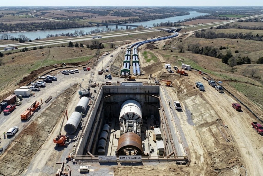
Horizontal directional drilling in Ardmore is how Main Street and Noble corridor owners pull duct and water under frontage asphalt without closing lanes that serve Texas-line traffic and Lake Murray tourism. Limestone and sandstone lenses on I-35 approaches change penetration rates mid-pull — steerable HDD with rock tooling contingency beats open cut when hard strata would stall a shallow trench crew.
Directional boring in Ardmore on I-35 and downtown stacks OG&E distribution, city water, and gas shallow on Carter County ROW. Oklahoma One-Call tickets and potholes at paint conflicts come before rig mobilization — not after a pit is half dug in southern red dirt.
Directional drilling in Ardmore along I-35 carries ODOT District 8 MOT and permit calendars that often outlast the physical bore. Duncan and Lawton corridor GCs spec HDD when frontage restoration on rock-heavy ROW would burn TI budgets.
Real Carter County angles — not generic statewide copy.
Post-paving TI cannot trench the full parking aisle to reach switchgear. HDD links vaults under asphalt with pits offset from striping.
Seasonal rise sheared PVC — steerable bore from meter to house entry without retrenching Cross Timbers shade.
ODOT widening stacks relocations under state ROW. HDD narrows lane closure footprints — MOT scoped before mobilization.
Warehouse feed crosses limestone lens between pads — cased approach ties into plant specs.
Ardmore HDD crews confirm survey and locate paint first — two business days minimum on One-Call before pits open, longer on I-35 ROW. Entry pits account for limestone near surface; mud weight tuned when sandstone appears on industrial pulls. Pilot, ream, and pullback monitored for buoyancy on long HDPE near Lake Murray.
Carter County red dirt, limestone, and sandstone with lake-bottom fill — harder southern profiles than eastern metro clay with groundwater on Murray approaches.
Ardmore bores encounter Carter County red dirt with limestone and sandstone lenses — penetration changes on I-35 commercial approaches and Lake Murray lowlands. Groundwater near the lake raises buoyancy risk on long HDPE pulls. Cross Timbers fringe adds intermittent rock sting without Lawton-style caliche dominance.
South-central heat and Cross Timbers humidity — summer dominates long I-35 pulls; spring storms soften lake-adjacent ROW around Lake Murray.
Summer heat dominates crew scheduling on long I-35 pulls. Spring storms soften lake-adjacent ROW briefly. Tourism-season traffic on Main and Noble affects MOT windows on commercial bores — we plan entry timing around weather and corridor use.
City of Ardmore Engineering, Carter County ROW, ODOT District 8 on I-35, Lake Murray flood and recreation rules on select routes.
City of Ardmore permits street and drive work inside limits. Carter County ROW on rural I-35 and US-70 approaches. ODOT District 8 controls state highway bores. Lake Murray shoreline work may need recreation and environmental review — scoped per alignment.
Open-cut across Main Street parking or a lake-area berm often costs more in asphalt, tree restoration, and business interruption than the bore. HDD wins when rock blocks shallow trench or when ODOT ROW limits trench width — open Cross Timbers pasture may still trench on price.
Footage, diameter, clay versus rock, dewatering, traffic control, permit fees, utility density, and rig class — quoted as drivers, not a menu price.
You share plans or describe the problem; we confirm alignment, depth, access, and which trenchless method fits Oklahoma soils.
Oklahoma One-Call ticket filed; two business days minimum before pits open unless your permit path differs. We pothole where marks conflict.
Bore plan, ODOT or city ROW permits, railroad agreements, and crossing engineering when the path leaves private property.
Compact spread for tight Edmond lots; larger HDD for I-35 or I-40 relocations — matched to length and diameter.
Steered pilot on design line, ream passes sized for your pipe or casing, fluid program tuned for clay or sand lenses.
HDPE fusion, steel casing, or multi-duct bundle pulled with tension and bend-radius monitoring.
Pressure test, mandrel, or survey records for owners, inspectors, and operators as spec requires.
Compact pits, replace sod or hardscape per scope, leave 811 ticket and locate map in your project file.
Length, diameter, limestone or sandstone, rock tooling, utility density, and MOT — not a flat per-foot rate. Main Street duct, lake lateral, and I-35 relocation use different spreads. Send alignment.
Yes — rock lenses and lake groundwater are planned for with tooling and mud; saturated banks may delay entry — we say so before booking steel.
Two full business days after ticket submission. I-35 commercial corridors often need remark and hand holes at OG&E conflicts.
Yes — south-central mobilization; permits and tap rules vary by address.
Shoreline-adjacent alignments need recreation and flood planning — scoped per route.
24/7 — Emergency dispatch statewide. Tell us entry, exit, pipe size, and county — a bore specialist calls back with cost drivers, not a flat rate.
Scope your bore path
Step 1 of 2 — path, pipe, and city first