BNSF casing east of Tulsa industrial corridor
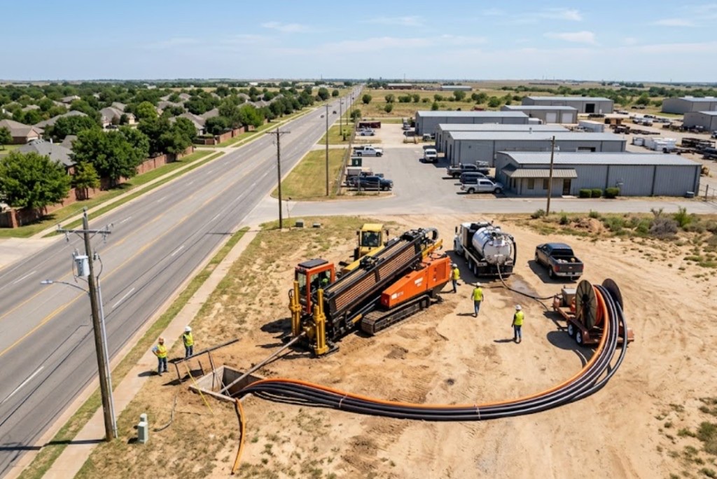
Railroad template with welded inspection and flagging — drive pit dewatering in variable fill near track grade.
Tulsa, OK · Tulsa County
Jack and bore casing on Tulsa rail spurs and levee toes — straight steel pushes when BNSF templates and floodplain specs require rigid carrier protection.
Auger boring in Tulsa fits BNSF agreements along the east industrial belt, storm outfalls toward the Arkansas River, and straight runs under approach slabs where casing grade matters more than steerable flexibility. Shored pits handle sandstone sidewalls and river-adjacent groundwater.
Directional boring in Tulsa handles curves and long HDPE on Brookside laterals; jack and bore wins when the engineer specifies welded casing under rail embankment or levee toe on a line-and-grade push. Railroad flagging windows often set the calendar before jack footage does.
City of Tulsa floodplain rules on river approaches favor cased crossings over open cut through saturated banks — auger bore scopes dewatering and inspection per levee district detail when applicable.
Real Tulsa County angles — not generic statewide copy.
Railroad template with welded inspection and flagging — drive pit dewatering in variable fill near track grade.
Straight RCP push where slope stability blocks open cut — groundwater and environmental holds scoped upfront.
Short rigid carrier under mixed-use hardscape — grade control on 50-foot push beats HDD tolerance on some municipal details.
ODOT detail with internal dividers for telecom and electric — jack sets shell before internal pulls.
Tulsa auger bore layouts pits on survey line after locates and shoring design for sandstone or wet alluvium. Casing advances with rotating head; railroad and floodplain inspections follow controlling agreements. Reception pit exposes face for carrier grout per city or ODOT detail.
Tulsa County mixes sandstone, siltstone, and claystone with sandy Arkansas River alluvium — variable bearing and groundwater along the river corridor.
Tulsa bores encounter Pennsylvanian sandstone and shale east and south of downtown, with softer alluvium and sand in Arkansas River bottoms. River-adjacent shots risk frac-out into the water table without proper mud weight. West toward Sand Springs and Sapulpa, claystone dominates with intermittent rock lenses that slow penetration without correct tooling. We pull geotech when city records are thin — especially on floodplain and levee approaches.
Arkansas River humidity, spring tornado season, and summer heat shape Tulsa bore schedules — lightning holds and post-storm saturated banks are planned into quotes.
Spring tornado season and Arkansas River flood stages are Tulsa's biggest calendar variables. Saturated river banks delay entry work; lightning shuts down rigs during severe weather. Summer humidity affects crew safety and fluid performance on long pulls along the IDL. We schedule around known wet seasons instead of forcing bores into unstable banks.
City of Tulsa Engineering Services, Tulsa County ROW, ODOT District 1, Arkansas River floodplain, and Creek Turnpike Authority permits appear on many metro bores.
City of Tulsa permits govern street cuts, drive removals, and floodplain work along the Arkansas River. Tulsa County handles ROW outside city limits toward Broken Arrow and Owasso. ODOT District 1 controls I-44 and US-75 state bores — MOT and night windows are common. Creek Turnpike Authority adds a layer on turnpike frontage. Railroad agreements on BNSF lines through the industrial corridor require separate timelines from 811.
Jack and bore preserves rail and highway width on straight obstacles. Curved HDPE without casing shifts to HDD. Open cut across BNSF ROW is rarely approved versus cased template.
Casing size, drive length, pit depth, groundwater, rail or highway flagging, and welding inspection.
You share plans or describe the problem; we confirm alignment, depth, access, and which trenchless method fits Oklahoma soils.
Oklahoma One-Call ticket filed; two business days minimum before pits open unless your permit path differs. We pothole where marks conflict.
Bore plan, ODOT or city ROW permits, railroad agreements, and crossing engineering when the path leaves private property.
Compact spread for tight Edmond lots; larger HDD for I-35 or I-40 relocations — matched to length and diameter.
Steered pilot on design line, ream passes sized for your pipe or casing, fluid program tuned for clay or sand lenses.
HDPE fusion, steel casing, or multi-duct bundle pulled with tension and bend-radius monitoring.
Pressure test, mandrel, or survey records for owners, inspectors, and operators as spec requires.
Compact pits, replace sod or hardscape per scope, leave 811 ticket and locate map in your project file.
Casing and straight alignments favor auger bore. Curved paths or long HDPE without casing favor HDD — engineer method note drives the call.
Jacking may finish in days; BNSF agreements and inspection often drive weeks-to-months lead.
Running sand in river alluvium without dewatering can stall progress — test pits help on floodplain approaches.
Yes when plans specify casing and straight gravity grade — large trunks may use microtunneling instead.
24/7 — Emergency dispatch statewide. Tell us entry, exit, pipe size, and county — a bore specialist calls back with cost drivers, not a flat rate.
Scope your bore path
Step 1 of 2 — path, pipe, and city first